UNESCO List is a major reference as a universally recognized source of World Cultural Heritage.
It covers tangible and intangible cultural heritage properties and elements among other entities. UNESCO sites in Iran already inscribed there and many more on the waiting list.
The United Nations Educational, Scientific and Cultural Organization (UNESCO) selected the tangible and intangible cultural heritage of all nations and inscribes them as entities having the cultural, historical, scientific or other forms of significance.
So, UNESCOmakes lists of such legacies of each nation under two major lists recognized globally.
Iran, as an ancient country in the Middle East, is the home to a huge number of such legacies. Iranian Cultural Heritage, Handicrafts, and Tourism Organization (ICHHTO) is the official body for the registration and preservation of cultural heritage in Iran.
Some of Iran’s UNESCO world heritage sites are historical and some are cultural rituals, customs, traditions, skills, etc. UNESCO sites in Iran are inherited from our ancestors several centuries ago.
UNESCO sites in Iran are Iranian legacy from the past, what they live with today, and what they pass on to future generations. Iranian cultural and natural heritage are both irreplaceable sources of life and inspiration.
The number of UNESCO sites in Iran are 24 and each has its own story to tell.
You need to embark on a trip through this ancient country to discover its complex culture, its people warm hospitality and the endless layers of history beneath the surface of this magnificent and fast-changing country.
UNESCO Sites in Iran
Iranian Tangible Cultural Heritage in UNESCO List
UNESCO sites in Iran which are listed by UNESCO cover a wide range of various types of properties from examples of architecture, engineering, city planning, to bazaars, sets of buildings, and etc.
In the table below you can read a summary of UNESCO Sites in Iran.
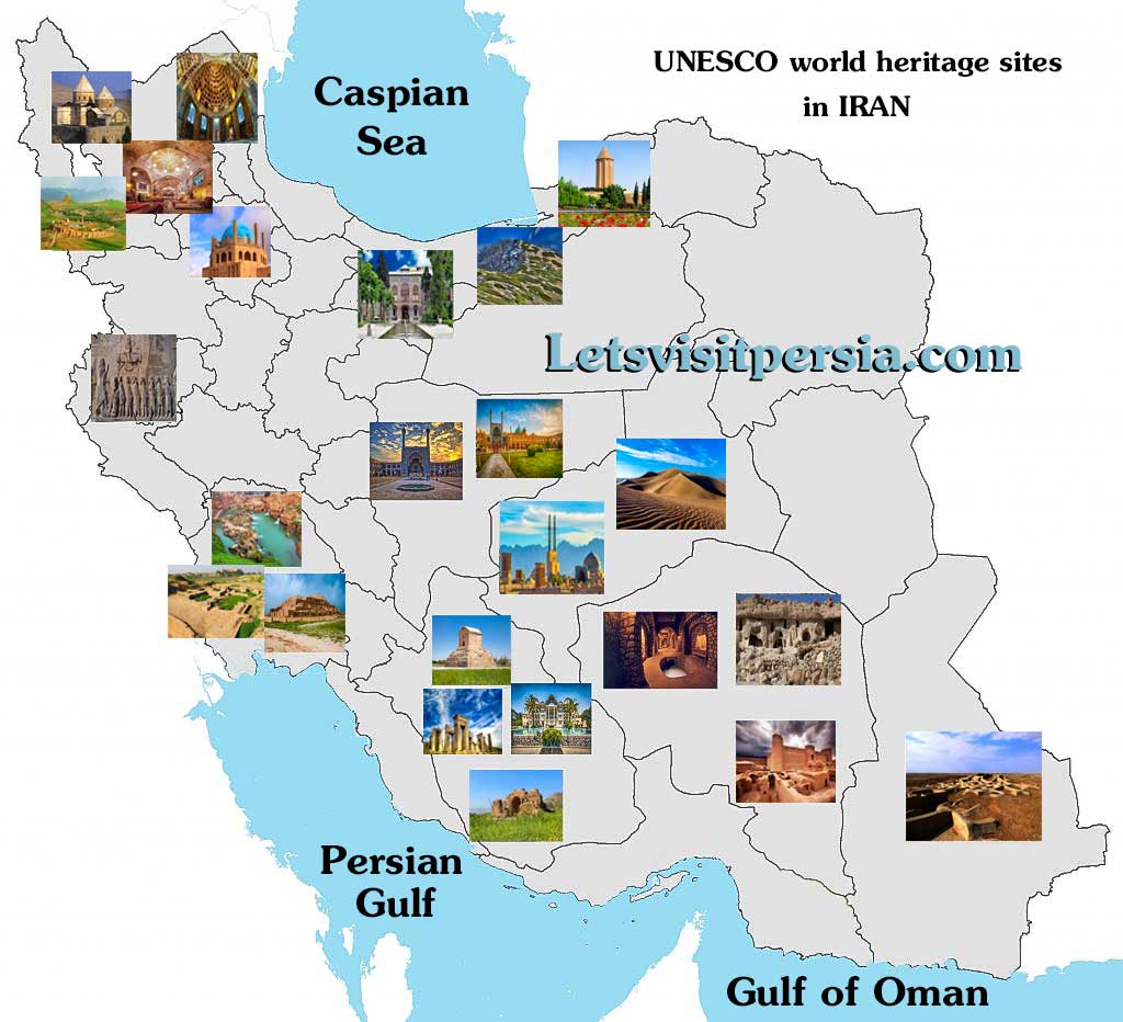
Armenian Monastic Ensembles
The Armenian Monastic Ensembles of Iran, in the north-west of the country, consists of three monastic ensembles of the Armenian Christian faith: St Thaddeus and St Stepanos and the Chapel of Dzordzor. These edifices – the oldest of which, St Thaddeus, dates back to the 7th century – are examples of the outstanding universal value of the Armenian architectural and decorative traditions. They bear testimony to very important interchanges with the other regional cultures, in particular, the Byzantine, Orthodox, and Persian. Situated on the south-eastern fringe of the Armenian cultural space.
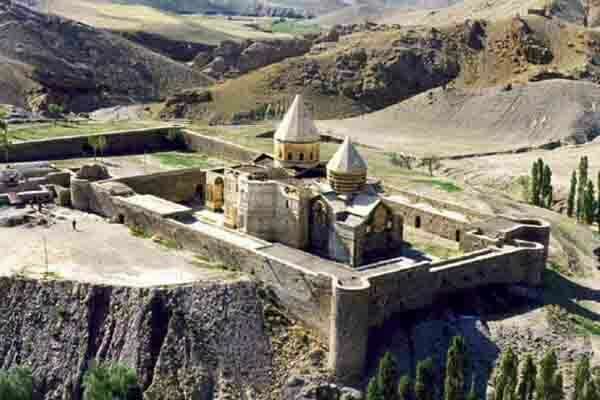
Bam and its Cultural Landscapes
Bam is situated in a desert environment on the southern edge of the Iranian high plateau. The origins of Bam can be traced back to the Achaemenid period (6th to 4th centuries BC). Its heyday was from the 7th to 11th centuries, being at the crossroads of important trade routes and known for the production of silk and cotton garments. The existence of life in the oasis was based on the underground irrigation canals, the qanāts, of which Bam has preserved some of the earliest evidence in Iran. Arg-e Bam is the most representative example of a fortified medieval town built by using mud layers (Chineh ).
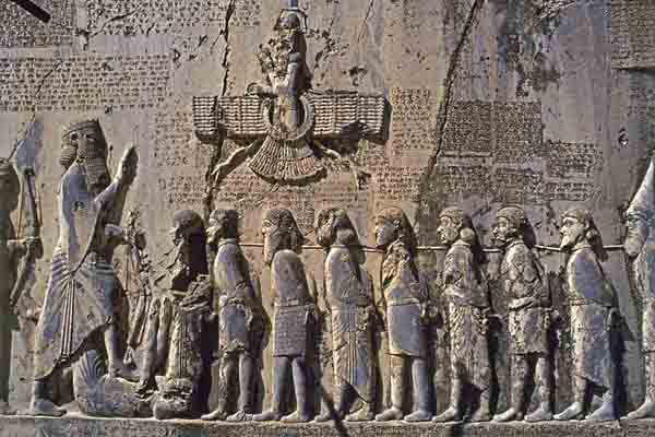
Bisotun
Bisotun is located along the ancient trade route linking the Iranian high plateau with Mesopotamia and features remains from the prehistoric times to the Median, Achaemenid, Sassanian, and Ilkhanid periods. The principal monument of this archaeological site is the bas-relief and cuneiform inscription ordered by Darius I The Great when he rose to the throne of the Persian Empire, 521 BC. The bas-relief portrays Darius holding a bow, as a sign of sovereignty, and treading on the chest of a figure who lies on his back before him.
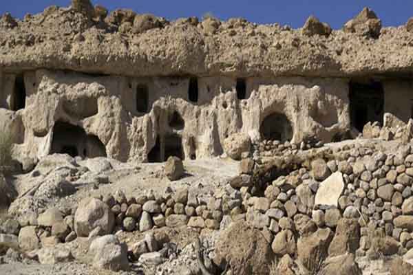
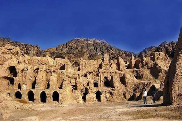
Cultural Landscape of Maymand
Maymand is a self-contained, semi-arid area at the end of a valley at the southern extremity of Iran’s central mountains. The villagers are semi-nomadic agro-pastoralists. They raise their animals on mountain pastures, living in temporary settlements in spring and autumn. During the winter months, they live lower down the valley in cave dwellings carved out of the soft rock (kamar), an unusual form of housing in a dry, desert environment. This cultural landscape is an example of a system that appears to have been more widespread in the past and involves the movement of people.
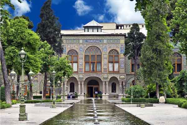
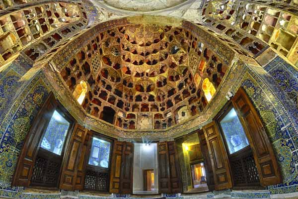
Golestan Palace
The lavish Golestan Palace is a masterpiece of the Qajar era, embodying the successful integration of earlier Persian crafts and architecture with Western influences. The walled Palace, one of the oldest groups of buildings in Teheran, became the seat of government of the Qajar family, which came into power in 1779 and made Teheran the capital of the country. Built around a garden featuring pools as well as planted areas, the Palace’s most characteristic features and rich ornaments date from the 19th century. It became a center of Qajari arts and architecture for Iranian artists and architects.
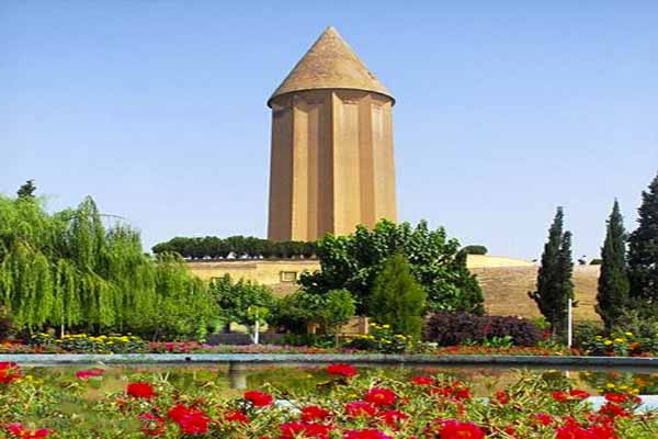
Gonbad-e Qābus
The 53 m high tomb built in ad 1006 for Qābus Ibn Voshmgir, Ziyarid ruler and literati, near the ruins of the ancient city of Jorjan in north-east Iran, bears testimony to the cultural exchange between Central Asian nomads and the ancient civilization of Iran. The tower is the only remaining evidence of Jorjan, a former center of arts and science that was destroyed during the Mongols’ invasion in the 14th and 15th centuries. It is an outstanding and technologically innovative example of Islamic architecture that influenced sacral building in Iran, Anatolia, and Central Asia.
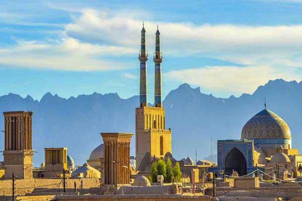
Historic City of Yazd
The City of Yazd is located in the middle of the Iranian plateau, 270 km southeast of Isfahan, close to the Spice and Silk Roads. It bears living testimony to the use of limited resources for survival in the desert. Water is supplied to the city through a qanat system developed to draw underground water. The earthen architecture of Yazd has escaped the modernization that destroyed many traditional earthen towns, retaining its traditional districts, the qanat system, traditional houses, bazars, hammams, mosques, synagogues, Zoroastrian temples and the historic garden of Dolat-abad.
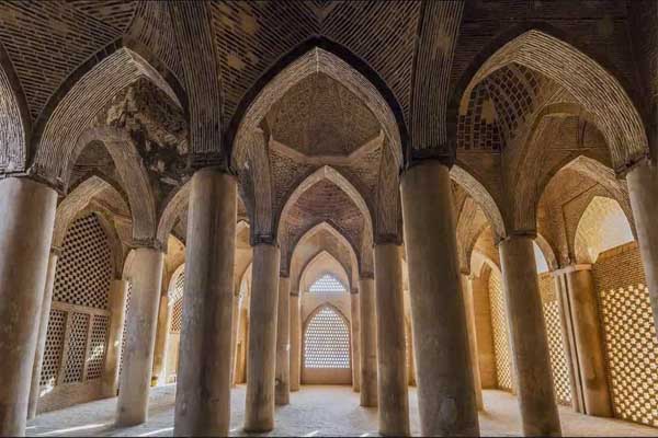
Masjed-e Jāmé of Isfahan
Located in the historic center of Isfahan, the Masjid-e Jāmé (‘Friday mosque’) can be seen as a stunning illustration of the evolution of mosque architecture over twelve centuries, starting in ad 841. It is the oldest preserved edifice of its type in Iran and a prototype for later mosque designs throughout Central Asia. The complex, covering more than 20,000 m2, is also the first Islamic building that adapted the four-courtyard layout of Sassanid palaces to Islamic religious architecture. Its double-shelled ribbed domes represent an architectural innovation that inspired builders throughout the region.
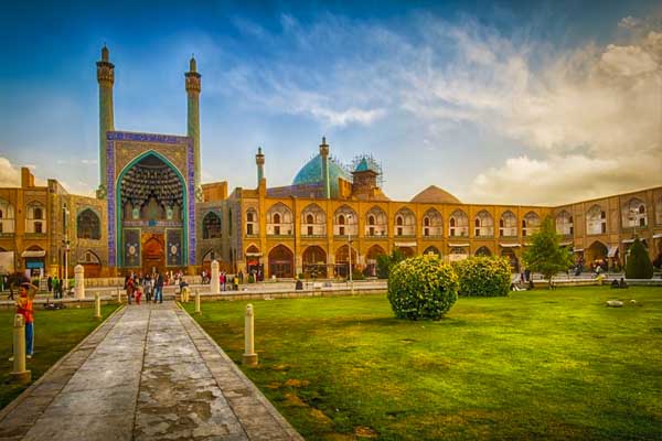
Meidan Emam, Esfahan
Also known as Meydan-e Naqsh-e Jahan ( Naqsh-e Jahan Square ) and formerly known as Shah Square by locals, built by Shah Abbas I the Great at the beginning of the 17th century, and bordered on all sides by monumental buildings linked by a series of two-storeyed arcades, the site is known for the Royal Mosque, the Mosque of Sheykh Lotfollah, the magnificent Portico of Qaysariyyeh and the 15th-century Timurid palace. They are an impressive testimony to the level of social and cultural life in Persia during the Safavid era which became one of the most beautiful cities of the world.
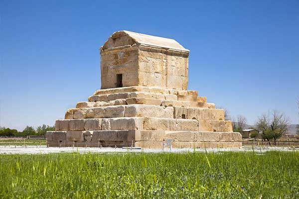
Pasargadae
Pasargadae was the first dynastic capital of the Achaemenid Empire, founded by Cyrus II the Great, in Pars, the homeland of the Persians, in the 6th century BC. Its palaces, gardens and the mausoleum of Cyrus are outstanding examples of the first phase of royal Achaemenid art and architecture and exceptional testimonies of Persian civilization. Particularly noteworthy vestiges in the 160-ha site include the Mausoleum of Cyrus II; Tall-e Takht, a fortified terrace; and a royal ensemble of gatehouse, audience hall, residential palace and gardens.
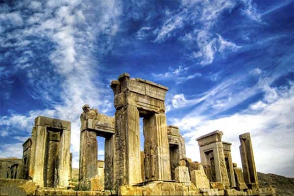
Persepolis
Founded by Darius I in 518 B.C., Persepolis was the capital of the Achaemenid Empire. It was built on an immense half-artificial, half-natural terrace, where the king of kings created an impressive palace complex inspired by Mesopotamian models. The importance and quality of the monumental ruins make it a unique archaeological site. Persepolis was built as a ceremonial capital and it was mostly used for the ceremonies especially the most popular one Nowruz which is celebrated by Iranian until today. Persepolis that was called the richest city under the sun was burned by the Alexander.
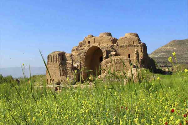
Sassanid Archaeological Landscape of Fars Region
The eight archaeological sites situated in three geographical areas in the southeast of Fars Province: Firuzabad, Bishapur, and Sarvestan. The fortified structures, palaces, and city plans date back to the earliest and latest times of the Sassanian Empire, which stretched across the region from 224 to 658 CE. Among these sites is the capital built by the founder of the dynasty, Ardashir Papakan, as well as a city and architectural structures of his successor, Shapur I. The archaeological landscape reflects the influence of Achaemenid and Parthian cultural traditions and of Roman art.
Shahr-e Sokhte
Shahr-i Sokhta, meaning ‘Burnt City’, is located at the junction of Bronze Age trade routes crossing the Iranian plateau. The remains of the mudbrick city represent the emergence of the first complex societies in eastern Iran. Founded around 3200 BC, it was populated during four main periods up to 1800 BC, during which time there developed several distinct areas within the city: those where monuments were built, and separate quarters for housing, burial, and manufacture. Diversions in watercourses and climate change led to the eventual abandonment of the city in the second millennium.
Sheikh Safi al-din Khānegāh and Shrine Ensemble in Ardabil
Built between the beginning of the 16th century and the end of the 18th century, this place of spiritual retreat in the Sufi tradition uses Iranian traditional architectural forms to maximize use of available space to accommodate a variety of functions (including a library, a mosque, a school, mausolea, a cistern, a hospital, kitchens, a bakery, and some offices). It incorporates a route to reach the shrine of the Sheikh divided into seven segments, which mirror the seven stages of Sufi mysticism, separated by eight gates, which represent the eight attitudes of Sufism.
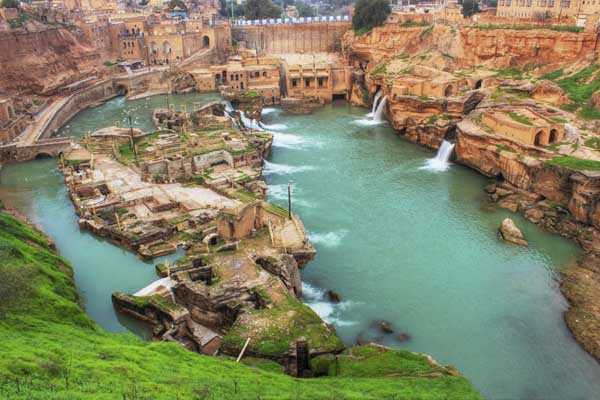
Shushtar Historical Hydraulic System
Shushtar, Historical Hydraulic System, inscribed as a masterpiece of creative genius, can be traced back to Darius the Great in the 5th century B.C. It involved the creation of two main diversion canals on the river Kârun one of which, Gargar canal, is still in use providing water to the city of Shushtar via a series of tunnels that supply water to mills. It forms a spectacular cliff from which water cascades into a downstream basin. It then enters the plain situated south of the city where it has enabled the planting of orchards and farming over an area of 40,000 ha. known as Mianâb (Paradise).
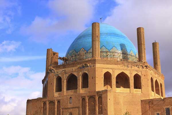
Soltaniyeh
The mausoleum of Oljaytu was constructed in 1302–12 in the city of Soltaniyeh, the capital of the Ilkhanid dynasty, which was founded by the Mongols. Situated in the province of Zanjan, Soltaniyeh is one of the outstanding examples of the achievements of Persian architecture and a key monument in the development of its Islamic architecture. The octagonal building is crowned with a 50 m tall dome covered in turquoise-blue faience and surrounded by eight slender minarets. It is the earliest existing example of the double-shelled dome in Iran.
Susa
Located in the south-west of Iran, in the lower Zagros Mountains, the property encompasses a group of archaeological mounds rising on the eastern side of the Shavur River, as well as Ardeshir’s palace, on the opposite bank of the river. The excavated architectural monuments include administrative, residential and palatial structures. Susa contains several layers of superimposed urban settlements in a continuous succession from the late 5th millennium BCE until the 13th century CE. The site bears exceptional testimony to the Elamite, Persian and Parthian cultural traditions which have disappeared.
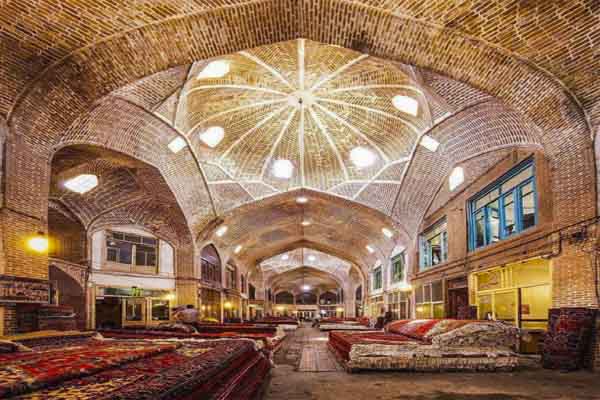
Tabriz Historic Bazaar Complex
Tabriz has been a place of cultural exchange since antiquity and its historic bazaar complex is one of the most important commercial centers on the Silk Road. Tabriz Historic Bazaar Complex consists of a series of interconnected, covered, brick structures, buildings, and enclosed spaces for different functions. Tabriz and its Bazaar were already prosperous and famous in the 13th century, when the town, in the province of Eastern Azerbaijan, became the capital city of the Safavid kingdom. The city lost its status as capital in the 16th century but remained important until the end of the 18th century.
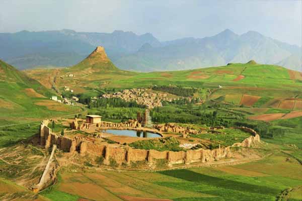
Takht-e Soleyman
The archaeological site of Takht-e Soleyman, in north-western Iran, is situated in a valley set in a volcanic mountain region. The site includes the principal Zoroastrian sanctuary partly rebuilt in the Ilkhanid (Mongol) period (13th century) as well as a temple of the Sasanian period (6th and 7th centuries) dedicated to Anahita. The site has important symbolic significance. The designs of the fire temple, the palace and the general layout have strongly influenced the development of Islamic architecture.
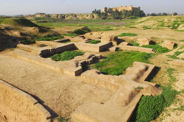
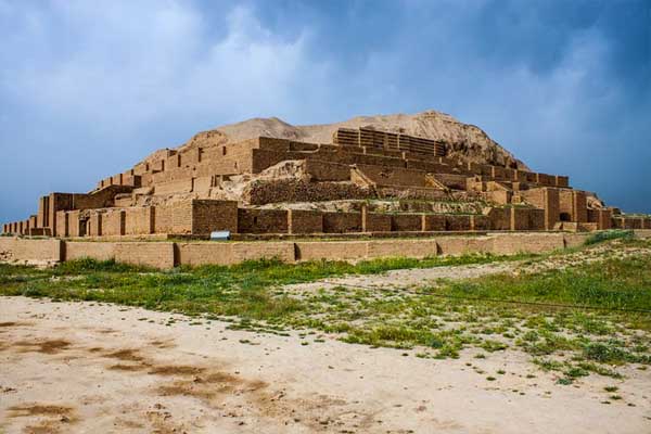
Tchogha Zanbil
The ruins of the holy city of the Kingdom of Elam, surrounded by three huge concentric walls, are found at Tchogha Zanbil. Founded c. 1250 B.C., the city remained unfinished after it was invaded by Ashurbanipal, as shown by the thousands of unused bricks left at the site. Located in ancient Elam (today Khuzestan province in southwest Iran), Tchogha Zanbil (Dur-Untash, or City of Untash, in Elamite) was founded by the Elamite king Untash-Napirisha (1275-1240 BCE) as the religious centre of Elam.
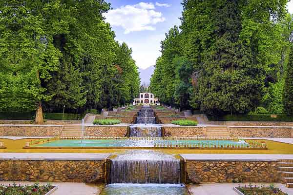
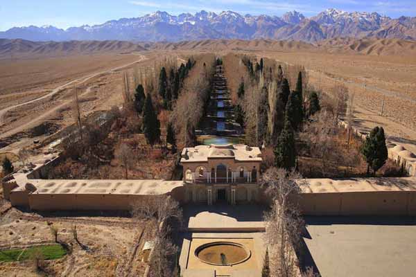
The Persian Garden
The property includes nine gardens in as many provinces. They exemplify the diversity of Persian garden designs that evolved and adapted to different climate conditions while retaining principles that have their roots in the times of Cyrus the Great, 6th century BC. Always divided into four sectors, with water playing an important role for both irrigation and ornamentation, the Persian garden was conceived to symbolize Eden and the four Zoroastrian elements of sky, earth, water, and plants. These gardens, dating back to different periods since the 6th century BC.
The Persian Qanat
Throughout the arid regions of Iran, agricultural and permanent settlements are supported by the ancient qanat system of tapping alluvial aquifers at the heads of valleys and conducting the water along underground tunnels by gravity, often over many kilometers. The eleven qanats representing this system include rest areas for workers, water reservoirs and watermills. The traditional communal management system still in place allows equitable and sustainable water sharing and distribution. The qanats provide exceptional testimony to cultural traditions and civilizations in desert areas and arid climate.
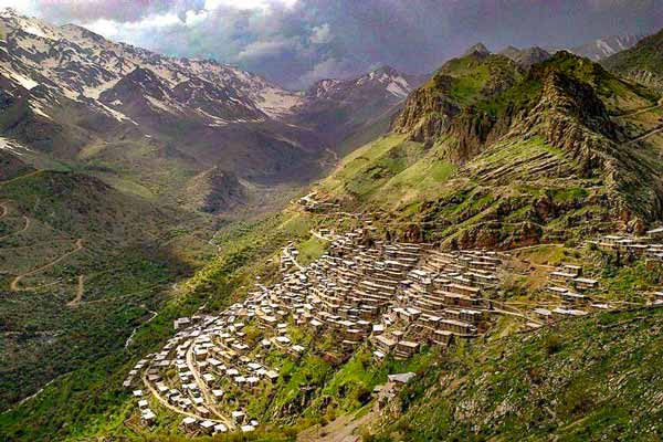
Cultural Landscape of Hawraman (Uramanat)
The remote and mountainous landscape of Hawraman (Uramanat) bears testimony to the traditional culture of the Hawrami people, an agropastoral Kurdish tribe that has inhabited the region since about 3000 BCE. The property, at the heart of the Zagros Mountains in the provinces of Kurdistan and Kermanshah along the western border of Iran.
The mode of human habitation in these two valleys has been adapted over millennia to the rough mountainous environment.
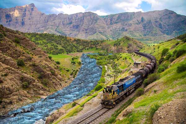
Trans-Iranian Railway
The Trans-Iranian Railway connects the Caspian Sea in the northeast with the Persian Gulf in the southwest crossing two mountain ranges as well as rivers, highlands, forests and plains, and four different climatic areas. Started in 1927 and completed in 1938, the 1,394-kilometre-long railway was designed and executed in a successful collaboration between the Iranian government and 43 construction contractors from many countries.
Unlike most early railway projects, construction of the Trans-Iranian Railway was funded by national taxes to avoid foreign investment and control.
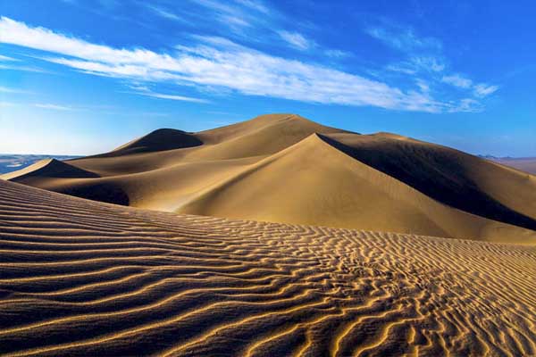
Lut Desert
The Lut Desert, or Dasht-e-Lut, is located in the south-east of the country. Between June and October, this arid subtropical area is swept by strong winds, which transport sediment and cause aeolian erosion on a colossal scale. Consequently, the site presents some of the most spectacular examples of aeolian yardang landforms (massive corrugated ridges). It also contains extensive stony deserts and dune fields. The property represents an exceptional example of ongoing geological processes. Lut Desert and Hyrcanian Forest are the only two natural Iran UNESCO sites.
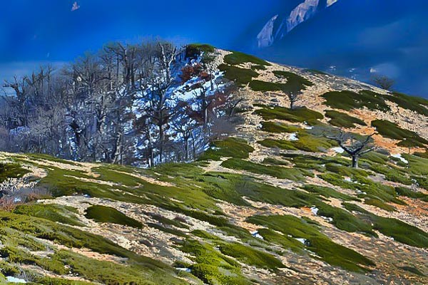
Hyrcanian Forests
Hyrcanian forests form a unique forested massif that stretches 850 km along the southern coast of the Caspian Sea. The history of these broad-leaved forests dates back 25 to 50 million years, when they covered most of this Northern Temperate region. These ancient forest areas retreated during the Quaternary glaciations and then expanded again as the climate became milder. Their floristic biodiversity is remarkable: 44% of the vascular plants known in Iran are found in the Hyrcanian region, which only covers 7% of the country.